Since the holidays might have brought someone some GPS type toys, I figured that I would recycle an older post of mine to share some information, and also add to it some new stuff I have found.
I use Apple Macintosh computers, and here are some tools I have found:
A commercial software package which is very powerful is MacGPS Pro. I have used it for land and marine based GPS mapping and charts. I consider it to be worth the money. It is not the simplest or most intuitive program, but it is very powerful and is loaded with features. It can import and use the topographical maps I mentioned above, and supports a fair amount of GPS devices.
TrailRunner is a neat application package that can be used for running, biking, hiking, and I plan on using it for Skiing too. It is "donation-ware" and looks to be quite a slick package. As I have not used it much, I am simply including it here as a reference. I hope to know more about it in a few weeks after I have played with it more.
GPS Babel is software that runs on just about any operating system, and is free. It will load and translate GPS data to and from many many many devices. Definitely worth checking out, and probably deserves a donation if it works out to be useful to you.
And if you are looking for street mapping on your Mac, and you want something available offline or other features, you can check out Route Buddy. The app is $100 and the maps are extra. I have not used it. But I figured I would include it for completeness. I figure this is similar to Microsoft Streets, or DeLorme Street Atlas, (or like the now abandoned mac app called Route66...).
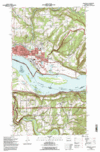
The Libre Maps project has purchased and made available for free all of the USGS Topographical maps of the USA. All 50 states.
The maps have always been free sort-of, there was just no where until now to actually GET them for free. The Libre Maps project raised enough funds to buy the many gigabytes of data and the Internet Archive is hosting them.
These are great 24k scale topographical maps folks. The same types you pay for in sporting goods stores. And many applications on your computers can work directly with them and your GPS. You can get water and tear resistant paper and print them out..
All good stuff...
For the lazy in the audience, here are Oregon's.


I use Apple Macintosh computers, and here are some tools I have found:
A commercial software package which is very powerful is MacGPS Pro. I have used it for land and marine based GPS mapping and charts. I consider it to be worth the money. It is not the simplest or most intuitive program, but it is very powerful and is loaded with features. It can import and use the topographical maps I mentioned above, and supports a fair amount of GPS devices.
TrailRunner is a neat application package that can be used for running, biking, hiking, and I plan on using it for Skiing too. It is "donation-ware" and looks to be quite a slick package. As I have not used it much, I am simply including it here as a reference. I hope to know more about it in a few weeks after I have played with it more.
GPS Babel is software that runs on just about any operating system, and is free. It will load and translate GPS data to and from many many many devices. Definitely worth checking out, and probably deserves a donation if it works out to be useful to you.
And if you are looking for street mapping on your Mac, and you want something available offline or other features, you can check out Route Buddy. The app is $100 and the maps are extra. I have not used it. But I figured I would include it for completeness. I figure this is similar to Microsoft Streets, or DeLorme Street Atlas, (or like the now abandoned mac app called Route66...).
Comments